Leros Island stretches 8 nautical miles in northwest and southeast directions with its greatest width in the north at 4.5 nautical miles. All along the coast, many natural bays are formed providing safe anchorage and many tiny rocky islets dot the horizon.
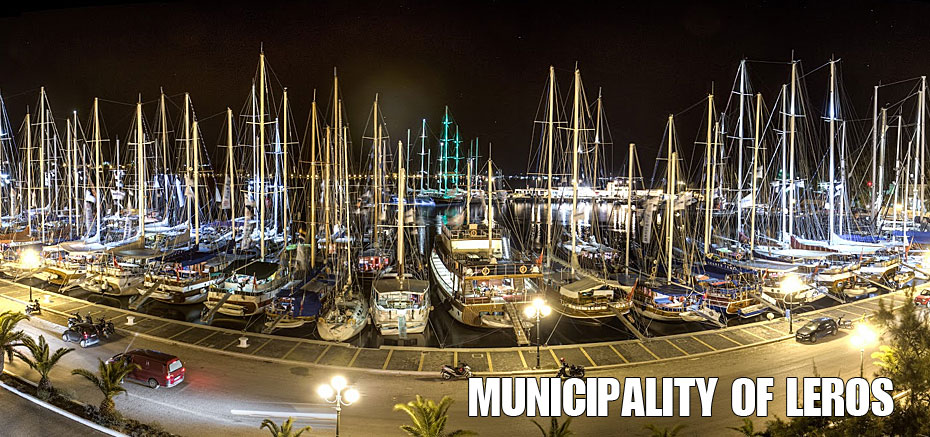
The most important bay is the deep Bay of Lakki. It is open to its southwest side and can be accessed from its northeast opening up to 2 nautical miles with a width in the middle of 0.5 nautical miles. It is considered the largest, safe natural harbour in the Mediterranean. At the east part of the bay’s northern coast, is the port and market town of Lakki. Near the commercial port and sheltered from the wind, there is an area specially designed for the anchoring of yachts and other pleasure craft.
At the safest part of Lakki bay there are (2) two Marina companies:
- Evros Marina, offers the opportunity for memorable moments, in a well known cruising & sailing area, the South Aegean Sea.
- Agmar Marine provides visitor anchorage with about 30 berths.
A number of services are available in both companies such as a laundry, a restaurant or a café for example.
A little further down the bay, one has access to all the services provided by the market town of Lakki with connections to other parts of the island, accommodations, car rentals shopping, restaurants and many other services. Also, boats can be supplied with water and fuel.
If you choose to anchor at the end of the bay, towards the north at Temenia, the same services will be provided by another company called Evros SA with 60 berths for the anchorage of yachts and other pleasure craft. This company also does any repairs that may be required. The bay and the port are protected from harsh eastern and western winds and are ideal spots for anchoring. The Port Authorities can be reached on channel 12 on your VHF transmitter. The customs’ office, shops with marine equipment, liquid gas, provisions and ice, are located in the immediate harbour area
In the eastern part of the island is the bay of Alinta, between Akra Aspro or Agia Marina in the north and Akra Kastello or Bourtzi to the south. The bay opens towards the east and is most accessible from the west for 0.9 nautical miles. It serves as an alternative port for the island primarily when there are strong southerly or south-westerly winds. It has rocky and sandy sections and is 10 metres deep and is sufficient for those who wish to drop anchor 0.1 -0.2 nautical miles from shore.
Along the south coast of the bay you will find the village of Alinta and a short distance from there is the island’s capital of Agia Marina. There are harbour breakwaters and a 60 to 70 metre pier with bollards for the securing of mainly ferries. Other conventional craft and speed boats can be secured here and is also appropriate for the mooring of smaller ships under normal weather conditions.
Anchoring is preferable in the middle of the bay at a depth of 4-6 metres. However, the bay is not generally safe when there are strong north to northwest seasonal, summer winds called “meltemia”. There is an exceptional view when approaching Alinta of the Castle and the four windmills, which stand on the hill above the village of Platanos.
Further south, to the southern part of Akra Pantelis, is the Bay of Panatela, which is open to the east and the south and it has a sandy seaweed bed. In the northern section, there is a fishing village going by the same name with a small harbour that is suitable for fishing boats and pleasure craft and yachts that will be protected to the south by a natural seawall. It is very good for anchoring when there are north winds, and in recent years during the last years it has became the favourite stop for many pleasure craft and yachts that are attracted to the picturesque fishing village, the chance to stock up and, most of all, the fish taverns, cafés and bars next to the small port.
In the western part of the northern shores of the island is the Bay of Partheni, with its entrance facing northwest with a width of practically 0.6 nautical miles. Inside this bay is the small port of Agia Matrona. It is safe for anchoring under any weather conditions, as it is protected to the northwest and north by the small island of Archangelos and the islets of Farios, Petalida and Tripiti, even when the northeast winds create extremely rough waters and high waves near the small port.
Here, services are available to leisure craft for seasonal wintering. It is best to anchor boats at a depth of 3 to 8 metres in the northern part of the bay, which faces east. In the southeast part of the island, Blefoutis Bay provides safe shelter from all the winds except those from east or south easterly directions. You can avoid the rock formations, which rise above the sea level by positioning your craft in the middle with the rock formations on the starboard and leeward sides of the boat. The depth of the bay along the side of the rock formations exceeds five metres. You can also, anchor in front of the small fishing village.
Finally, you can anchor in the southern part of the island, in the deep Bay of Xerokambos. You will enjoy swimming and diving into the crystal, clear waters, and the tasty fish from the local taverns, as well as being protected from the seasonal, summer “meltemi” winds, as the bay is open only on its south side. Here, you can also try your hand at spear - fishing.

")


")